Posts

Showing posts with the label English posts

Roadmap: Real Sense Application

Image
The RealSense application is a solo project combined many different components I created during my job in the road surveying company As the idea of the project is to let colleagues can measure objects such as road width, sidewalk, and even cracks. Since the implementation can't simply program through it, this project has: Hardware selection, Computer Vision, Location Service, Depth Camera Library, GUI visualization Further development with ArcGIS/QGIS plugin creation, Flask web-framework

Raspberry Pi + Realsense: MIT App Inventor

Image
So when I found this, this is my savior with no knowledge of JAVA I thought an app is impossible but I found this youtube video this showed that with Request of Simple HTTP server and GET request I can connect them So he's the inspiration of the whole project, thanks ADEL KASSAH!!

Raspberry Pi + Realsense: Git

Image
So I finally get the chance to work on git more often. before just working one the same laptop, or copy it to another like a noob. Since Pi is not connected to the company network of files, and I dont have more usb sticks around, I use git now

Raspberry Pi + Realsense: Usage of class, PyQT

Image
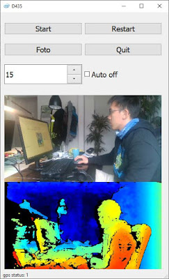
So not only did this project helped me know more about tcp transmission and also helped my old scripts I based on the structure and with minimum change I made a pyQT version of the camera app

Raspberry Pi + Realsense: Flask server

Image
I would start first with the easy part, Flask Flask is a micro framework to set up at server, app and without setup like the whole Django file structure framework. The good part is the variable they use is quite similar, because template of jinja2 and django is very similar the code:  https://github.com/soarwing52/Remote-Realsense/blob/master/flask_server.py

Project introduction: Tablet control Raspberry Pi with Realsense Depth Camera

Image
The whole Realsense D435 project started long ago, I was working with it the whole year actually, and I have more records I started on my working laptop, then need to run it on old road survey laptop, which is a lot weaker and with a long usb cable connecting from the laptop on the side seat to the camera set on the front top of the car, it is just not as satisfying. As the new pi has usb3 port, this is a good choice to update the things a bit. the final result is on Github

Raspberry Pi - start without HDMI adapter

Image
So, after the "mind blowing" fair we went in Stuttgart, we started to push something new The thing is what I've been saying for a long time: Raspberry Pi 4 As currently the adapter is not here yet, I tried to start without it connecting to hdmi directly

RealSense learning/turtorial/sharing blog - Chapter Five: Measuring

Image
The math of the distance between two points is really easy, just square(x^2 +y^2 +z^2) but how to implement it into the program and let it show on a GUI, then combine with GIS platform is the task

RealSense learning/turtorial/sharing blog - Chapter Four: Frame Issues

Image
What is the next step after getting the frames? while examining the collected data, there are some issues needed to be fixed, and this post will focus on this part The visualization will use openCV and the example file will be: https://github.com/soarwing52/RealsensePython/blob/master/phase%201/read_bag.py

RealSense learning/turtorial/sharing blog - Chapter Three: Frame control

Image
In the last post  we finished the adjustments of the camera This part will work on the frames. getting the frames is the first step of the data Explaining the content of the frame class and its instinces

Using App-templates of ArcGIS Online - Geoform & Crowd source Reporter

Image
ESRI now provides various resources and templates for users for spatial usage And as how to connect data to people is one important part, and our project is to create a system, where users can submit their comments about ourplannings. So, Geoform and Crowd source reporter is tested, and here are some experiences and tipps.

Creating Survey123, and the data for other ArcGIS Online usages

Image
The previous article is a summary and comparison of choices This part will explain what will be created and some usages, opinions To start with Survey123, the clearance of Web-Survey and App-Survey is important

Using Smart Editor to create a survey form in ArcGIS Online

Image
The previous article is a summary and comparison of the option in ArcGIS Online This part will focus on the settings of the Smart Editor. The online tutorials shown that some would require a standard license, but it is actually achievable with basic license, with the rest settings online.

Methods to collect data from users in ArcGIS Online: Survey123, Geoform, Crowd-source reporter app, and Smart Editor

Image
The background of this task is to collect comments from the residents about our planning. And the final result will be about Survey123, Geoform, Crowd-source reporter app, and smart editor. In our system we provide a list of features as basemap and information, combining with our analysis and planning, deployed as an ArcGIS Webmap, and serve to the citizens. The original system before is that ObjectID is shown on the map as Labels, and the citizens will type in their name, email, road ID and their comments. Then the server will send this email to our company mailbox, and our staff will collect them into one excel file. road ID on map

RealSense learning/turtorial/sharing blog - Chapter Two: More Device Adjustments

So, after the hello world, more controls over the device. So the pipeline is basically start/stop, and wait_for_frames And the function of pipeline_profile I haven't know yet in this part I will put in the controls before wait_for_frames, including record file, read file, and others

RealSense learning/turtorial/sharing blog - Chapter One:The Start, Install and Hello World

Image
It's been one month I’ve been working on this Intel realsense D435, and still I’m not so sure with a lot of functions and some parameters. Like when to add () and when not, which function need which parameter to fit in. First I read the https://buildmedia.readthedocs.org/media/pdf/pyrealsense/dev/pyrealsense.pdf And the python.cpp in the python wrapper to find the options Actually it didn't help much, mainly I started with the examples in python wrapper and then read the corresponding codes in the C++ example. It is also because this project is to measure objects in the picture, and in the example there is already one measuring in stream, so translating that code is the first approach. And here https://pyrealsense.readthedocs.io/en/master/index.html

2016/10-2019/01 the house of Adam-Opel

Image
Well well well, this is a house of stories two years in here, gives me a lot of adventures so this is the article for "public-available stories"

Chapter Frankfurt: one step of life, people come, and leave

Chapter Frankfurt: in this part of the story, I lived a different life, even for a student in Germany. The house of Adam-Opel-Straße, is where it started, brings us happiness and pain in the ass. And the reason my life can be such an adventure.

How I crossed Switzerland(8) - Liechenstein

Image
It's the last day biking and actually we also biked a lot some unexpected things happened, and we were drained again what is it? let's peddal

How I crossed Switzerland(7) - Luzern to Liechenstein

Image
So what was our decision of destination for today? It's in the title, Liechtenstein!! another 135 km and to another country! Are we insane? no

Contact Me!